


The Pakistan political map is an essential geographic and administrative representation of the country, outlining its provinces, territories, federal areas, and international borders. Whether you are a student, researcher, educator, traveler, or someone interested in geopolitics, understanding Pakistan’s political map is critical for gaining insight into how the country is governed and organized.
This detailed guide explains the structure, importance, and components of the Pakistan political map, while also exploring its provinces, administrative divisions, disputed regions, and international boundaries.
What Is a Pakistan Political Map?
A Pakistan political map visually displays the country’s administrative divisions rather than physical features like mountains or rivers. It highlights:
- National boundaries
- Provincial borders
- Federal territories
- Capital cities
- Major administrative centers
Unlike physical maps, political maps focus on governance and jurisdiction. They help users understand how authority is distributed across regions and how provinces and territories interact within the federal system of Pakistan.
Importance of the Pakistan Political Map
The Pakistan political map holds significance in multiple domains:
- Educational Value
Students rely on political maps to learn about provinces, capitals, and administrative divisions. It is a fundamental part of geography, civics, and Pakistan Studies curricula.
- Administrative Understanding
Government institutions use political maps to define jurisdictional boundaries for governance, elections, census data, and public administration.
- Geopolitical Awareness
The map provides clarity on Pakistan’s international borders and disputed territories, making it crucial for understanding regional and global politics.
- Planning and Development
Urban planners, NGOs, and policymakers depend on political maps to design infrastructure, allocate resources, and implement development projects.
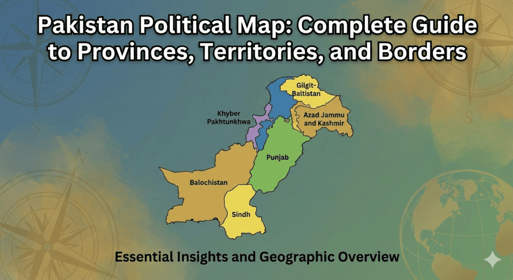
Provinces of Pakistan on the Political Map
The Pakistan political map officially recognizes four provinces, each with its own provincial government and capital.
Punjab
Punjab is the most populous province of Pakistan and plays a central role in the country’s economy and politics.
- Capital: Lahore
- Key cities: Faisalabad, Rawalpindi, Multan
Punjab is known for agriculture, industry, and cultural heritage.
Sindh
Located in the southeastern region, Sindh is an economic powerhouse due to its coastline and ports.
- Capital: Karachi
- Key cities: Hyderabad, Sukkur
Karachi, Pakistan’s largest city, is also its financial and commercial hub.
Khyber Pakhtunkhwa (KP)
Situated in the northwest, KP is known for its mountainous terrain and strategic importance.
- Capital: Peshawar
- Key cities: Mardan, Abbottabad
KP shares a border with Afghanistan and plays a key role in regional security.
Balochistan
Balochistan is Pakistan’s largest province by area but least populated.
- Capital: Quetta
- Key cities: Gwadar, Turbat
It is rich in natural resources and holds strategic importance due to the Gwadar Port.
Federal Territories on the Pakistan Political Map
In addition to provinces, the Pakistan political map includes federal territories that are governed directly by the federal government.
Islamabad Capital Territory (ICT)
Islamabad is Pakistan’s capital and administrative center.
- It hosts major government institutions, embassies, and diplomatic missions.
- The territory is separate from Punjab for administrative neutrality.
Gilgit-Baltistan
Located in the northernmost region, Gilgit-Baltistan is known for its mountainous landscape.
- It borders China, Afghanistan, and India.
- Although not a province, it has a self-governance structure.
Azad Jammu and Kashmir on the Political Map
Azad Jammu and Kashmir (AJK) is a self-governing territory administered by Pakistan.
- Capital: Muzaffarabad
- It has its own president, prime minister, and legislative assembly.
AJK appears on many Pakistan political maps with a distinct boundary style due to its disputed status in the broader Kashmir conflict.
Disputed Territories and International Sensitivities
One of the most complex aspects of the Pakistan political map is the inclusion of disputed regions.
Kashmir Dispute
The Kashmir region is claimed by both Pakistan and India. Political maps may show:
- Line of Control (LoC)
- Differentiated boundaries
- Neutral shading to reflect dispute
The representation of Kashmir varies depending on the map’s source and intended use.
International Borders of Pakistan
The Pakistan political map also outlines the country’s international boundaries with four neighboring countries.
Border with India
- Located to the east
- Includes Punjab and Sindh boundaries
- Highly sensitive due to historical and political tensions
Border with Afghanistan
- Located to the northwest
- Known as the Durand Line
- Significant for trade, migration, and security
Border with Iran
- Located to the southwest
- Important for energy cooperation and regional trade
Border with China
- Located in the north
- Known for the Karakoram Highway
- Strategic partnership highlighted through the China-Pakistan Economic Corridor (CPEC)
Administrative Divisions Beyond Provinces
The Pakistan political map can also show subdivisions such as:
- Divisions
- Districts
- Tehsils
These smaller units are important for local governance, elections, and census operations. District-level political maps are commonly used by government departments and researchers.
Digital and Printable Pakistan Political Maps
With technological advancements, Pakistan political maps are available in various formats:
Digital Maps
- Interactive and zoomable
- Used in GIS systems, educational platforms, and mobile apps
Printable Maps
- Used in schools, offices, and publications
- Often simplified for clarity
When choosing a map, it is important to ensure it is updated and follows official government standards.
Uses of Pakistan Political Map in Daily Life
The Pakistan political map is not limited to academic use. It is widely used in:
- School and university education
- Competitive exams
- Travel planning
- Media and journalism
- Research and data visualization
Understanding the political map helps individuals make informed decisions and develop geographic awareness.
Conclusion
The Pakistan political map is a vital tool for understanding the country’s administrative structure, governance, and geopolitical position. From provinces and federal territories to disputed regions and international borders, the political map provides a clear framework of Pakistan’s national organization.
Whether you are a student, educator, researcher, or general reader, a thorough understanding of Pakistan’s political map enhances your geographic knowledge and civic awareness. As Pakistan continues to evolve, its political map remains a cornerstone for learning, planning, and policy-making.